Yorkhill and Anderston
The profiles on these pages provide a comprehensive overview of health and wellbeing in Glasgow. There are 60 profiles in total, covering Glasgow as a whole, the three sub-sectors of the city (North East, North West and South Glasgow) and 56 neighbourhoods across the city. They highlight differences in health and life circumstances across the city for a range of indicators organised under broad themes: population; cultural factors; environment and transport; socioeconomic factors; education; poverty; and health. The profiles are intended to be a resource for local communities and to inform action at neighbourhood level.
Yorkhill and Anderston
Children and Young People's Profile
Download a printer friendly version of this profile (pdf)
Yorkhill and Anderston has a population of 4,796 children and young people (aged 0-24 years).

Neighbourhood Comparisons with Glasgow
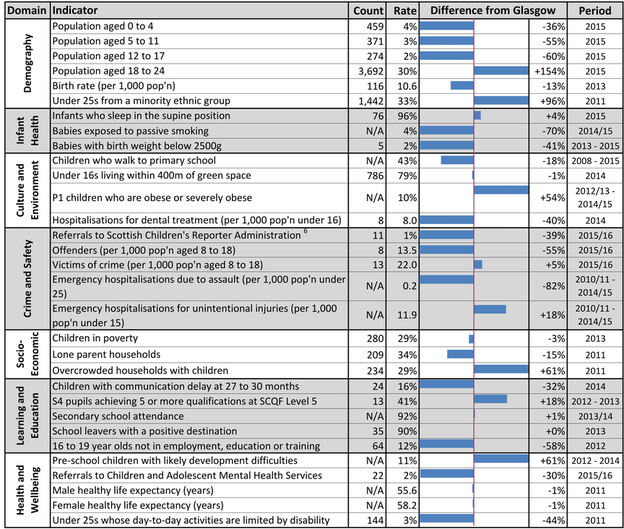
The proportion of school age children in Yorkhill and Anderston is markedly lower than Glasgow overall but 18-24 year olds make up 30% of the population. 33% of under 25s are from a minority ethnic group. 79% of children live within 400m of green space. The neighbourhood has fewer babies exposed to passive smoking (-70%) and offenders (-55%) but more overcrowding (+61%) than in Glasgow overall, as well as higher levels of obesity in P1 children (+54%). S4 pupil attainment is higher (+18%) than the Glasgow average and fewer 16-19 year olds are not in employment, education or training (-58%). Likely development difficulties in pre-school children are higher than the Glasgow average (+61%) but communication delay in young children is lower than average (-32%).

Neighbourhood Trends

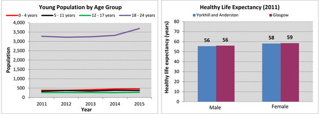
The number of 0-24 year olds in Yorkhill and Anderston has increased by 13% since 2011, with the largest increases being among 0-4 year olds (21%) and 18-24 year olds (13%). Healthy life expectancy for males is on a par with Glasgow as a whole and is approximately 1 year lower for females.

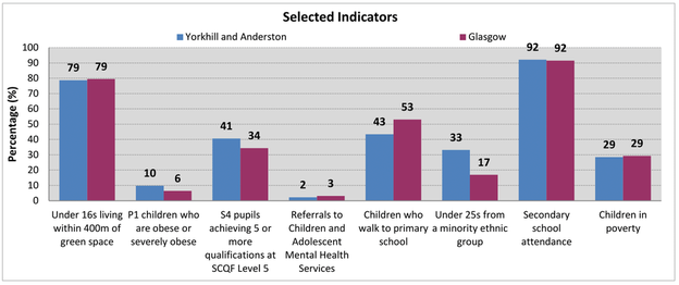
Pupil attainment and P1 obesity levels in Yorkhill and Anderston are higher than in Glasgow overall, while child poverty is on a par with the Glasgow average. The number of children living in proximity to green space is similar to Glasgow overall but primary school children are less likely to walk to school. The proportion of children and young people from minority ethnic groups is higher than the Glasgow average and referrals to children and adolescent mental health services are lower.
Notes
1. Data sources: Census 2011, GCPH, Glasgow City Council, HMRC - Child Poverty Unit, ISD Scotland, National Records of Scotland (NRS), Transport Scotland, Sustrans, Police Scotland, the Scottish Government and the Urban Big Data Centre, Glasgow University.
2. Indicators are aggregated using latest available datazone (2001 or 2011); neighbourhood boundaries based on 2001 datazones.
3. All count figures of less than 5 (denoted as ‘< 5’) have been suppressed to avoid any potential identification.
4. Populations presented in the population trend chart, also used to calculate healthy life expectancy estimates, use NRS small area population estimates for the years 2011 - 2015.
5. ‘Healthy life expectancy’ is an estimate of the average number of years people are likely to spend in good health. It is calculated using population estimates, death registrations and self-assessed health from the 2011 Census.
6. Denotes children referred to the Scottish Children’s Reporter Administration for an offence or non-offence related reason.
There is a downloadable document providing detailed notes and definitions on the information presented in this profile.
There is a downloadable Excel workbook containing the data used in all of the profiles. This workbook also includes alternative output formats and further breakdowns of some of the variables.


