
Children and young people's profiles (2026)
North East Sector
South Sector
North West Sector
Sighthill, Roystonhill and Germiston
Springburn
Balornock and Barmulloch
Robroyston and Millerston
Blackhill and Hogganfield
Ruchazie and Garthamlock
Easterhouse
Baillieston and Garrowhill
Mount Vernon and East Shettleston
Tollcross and West Shettleston
Springboig and Barlanark
Riddrie and Cranhill
Haghill and Carntyne
Dennistoun
Calton and Bridgeton
Parkhead and Dalmarnock
Toryglen
Ibrox and Kingston
Greater Govan
North Cardonald and Penilee
Bellahouston, Craigton and Mosspark
Pollokshaws and Mansewood
Newlands and Cathcart
Crookston and South Cardonald
Govanhill
Corkerhill and North Pollok
Priesthill and Househillwood
South Nitshill and Darnley
Carmunnock
Arden and Carnwadric
Greater Gorbals
Pollokshields East
Pollokshields West
Shawlands and Strathbungo
Langside and Battlefield
King's Park and Mount Florida
Castlemilk
Croftfoot
Cathcart and Simshill
Kelvindale and Kelvinside
Maryhill Road Corridor
North Maryhill and Summerston
Ruchill and Possilpark
Lambhill and Milton
City Centre and Merchant City
Yorkhill and Anderston
Hillhead and Woodlands
Hyndland, Dowanhill and Partick East
Broomhill and Partick West
Anniesland, Jordanhill and Whiteinch
Yoker and Scotstoun
Knightswood
Blairdardie
Drumchapel
Temple and Anniesland
*Please note that this profile is based on data from the 2022 Census.*
Download a printer-friendly version of this profile here
Download the 2022 children and young people neighbourhood profiles notes and definitions here
Glasgow has a population of 190,090 children and young people (aged 0–24 years).
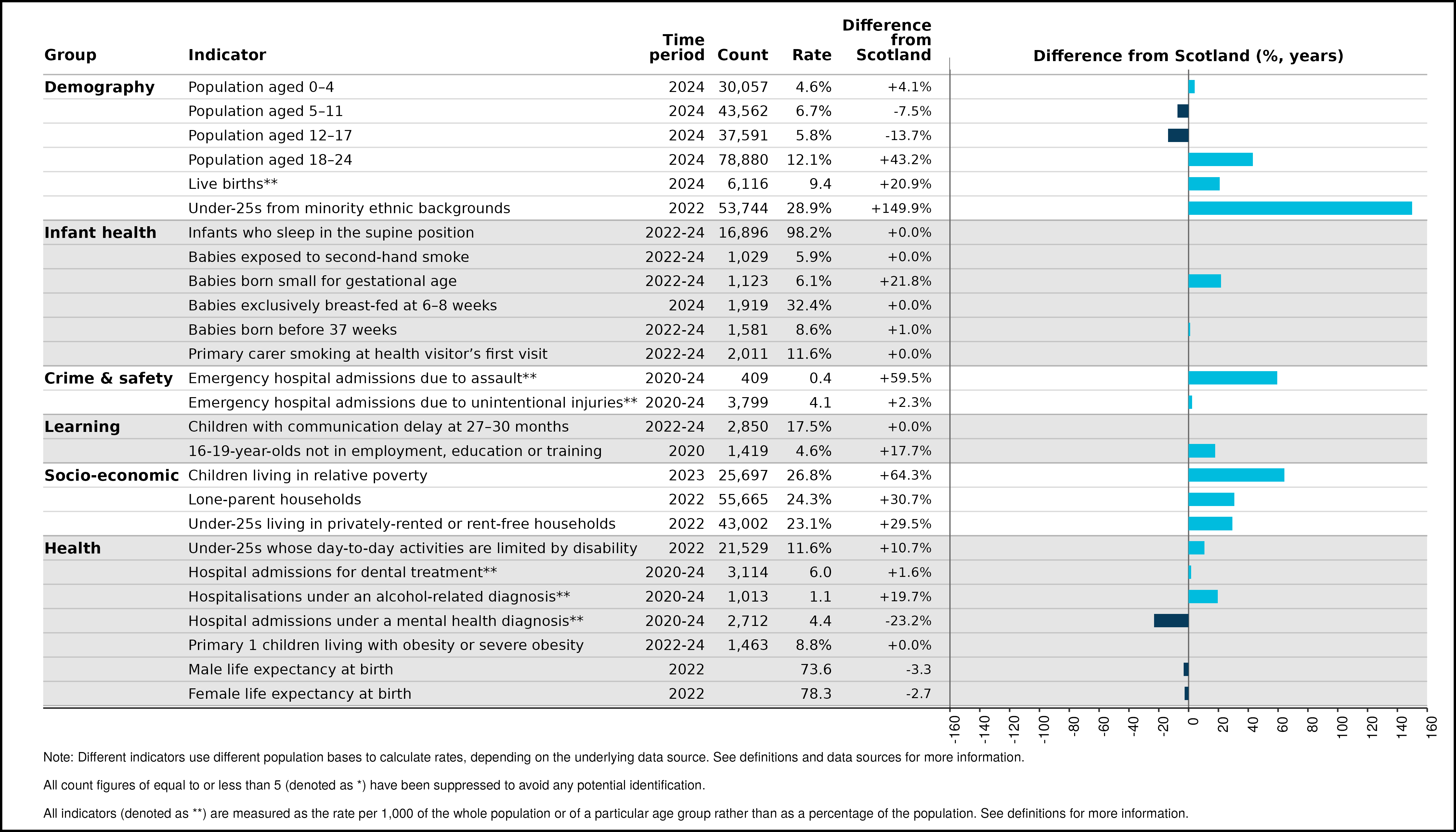
There is a high proportion of 18–24-year-olds in Glasgow, 43% higher than the Scottish average. Children and young people from minority ethnic backgrounds make up 29% of the population, 150% higher than the Scottish average. Children living in relative poverty, lone-parent households and under-25s living in privately-rented or rent-free households are all higher than the Scottish average, 64%, 31% and 30% higher respectively. Life expectancy in 2022 is lower for both sexes than the Scottish averages.
Glasgow comparison with Scotland
Neighbourhood trends
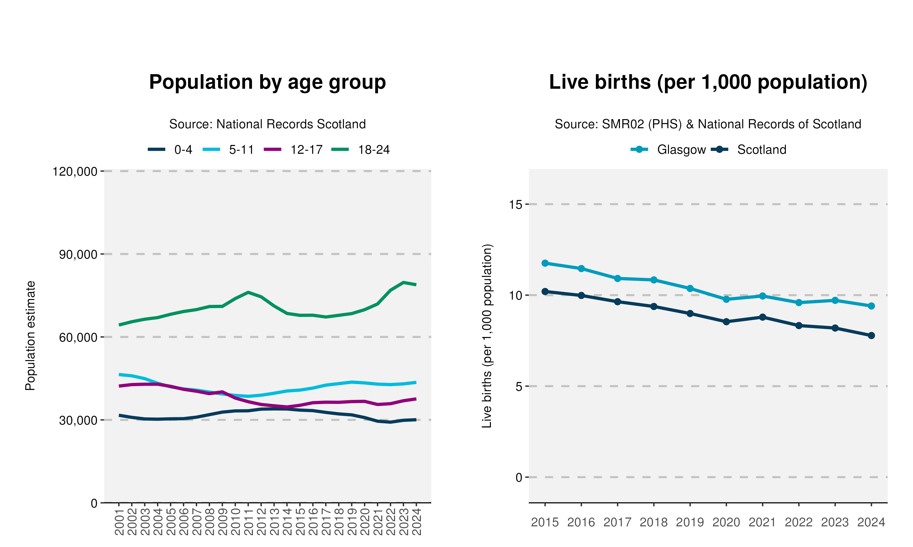
Since 2001, Glasgow’s population has grown by 3%. This overall increase is largely due to a 23% rise in the 18–24 age group, which was the only age group to see growth during this period. Glasgow shows a steady decline in the number of live births since 2015 but has consistently remained above the Scottish average.
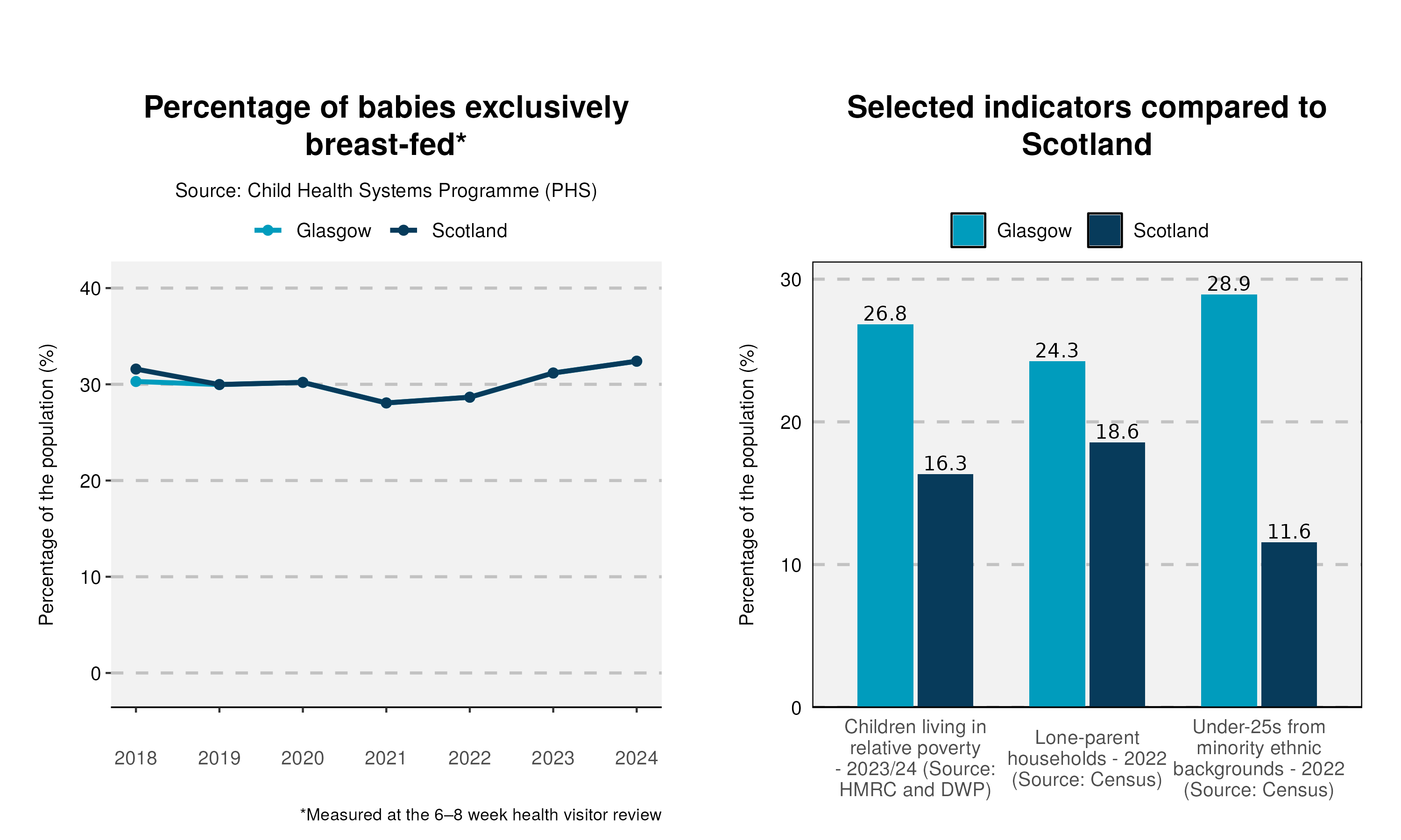
In Glasgow, 32% of babies reviewed in 2024 were exclusively breast-fed at 6-8 weeks. The Glasgow and Scottish averages are similar and remain relatively unchanged over time. The percentage of children living in relative poverty, lone-parent households and under-25s from minority ethnic backgrounds are all above the Scottish average.
Notes
An Excel workbook containing the data used in all of the profiles can be downloaded here. This workbook also includes alternative output formats and further breakdowns of some of the variables.
1. Data sources: Scottish Index of Multiple Deprivation (SIMD) 2020; Census (2001, 2011 and 2022); National Records of Scotland (NRS); Scottish Morbidity Records (SMR01 and SMR02); Child Health Systems Programme (CHSP) and CHSP Schools; Department for Work and Pensions (DWP); HM Revenue and Customs (HMRC).
2. All count figures of less than five (denoted as *) have been suppressed to avoid any potential identification.
3. This publication has used small area population estimate data published by the NRS on 24 February 2026. This is presented in the population trend chart and used to calculate life expectancy estimates. The NRS update their small area population estimates and previous estimates on an annual basis therefore this data is only representative of the data published upon this date. For further information see: https://www.nrscotland.gov.uk/publications/small-area-population-estimates-mid-2023-and-mid-2024-2011-data-zones/
4. Life expectancies are calculated based on population estimates and death registrations. 95% confidence intervals have been added on the graphs to the neighbourhood data to give an indication of their accuracy. The 95% confidence interval for the Glasgow and/or Scotland comparison line has been removed due to the size of the population. This resulted in the confidence interval sitting on the data line making it unreadable. The x-axes of the life expectancy graphs give the mid-year for each life expectancy estimate e.g. 2020 represents the life expectancy estimate for the period 2018-2022.
5. A notes and definitions document providing further information on the variables presented in the profile can be found in the Profiles section of the Understanding Glasgow website: https://www.understandingglasgow.com/profiles/children-young-people-s-profiles.